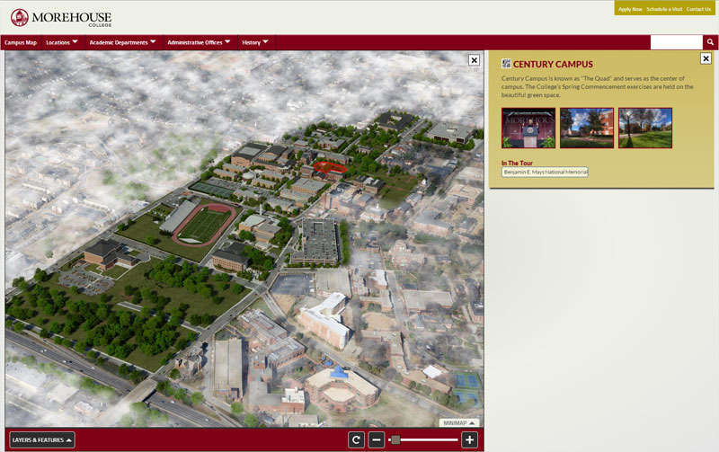
 CLICK HERE TO LAUNCH THE MOREHOUSE COLLEGE INTERACTIVE MAP EXPERIENCE WATCH PRESIDENT OBAMA'S 2013 MOREHOUSE COLLEGE COMMENCEMENT ADDRESS View new HTML5 virtual tours and photo-realistic 3D maps created by CampusTours The Morehouse College interactive map features a new photo-realistic 3D campus map drawn by CampusTours cartographers that depicts trees, shrubs, people, statues and locations with stunning clarity. CampusTours artists rendered the Morehouse College campus using three-dimensional software and then painstakingly applied accurate textures and shading to produce this lush campus map. The new map will be used in print as well as online. According to CampusTours visitor surveys, photorealistic maps like the Morehouse College map consistently rate highest among all campus maps. CampusTours new AnyMap 3.0 ushers in a new age in interactive maps, built completely in HTML5, supporting full browser display, mobile devices, campus directions, improved data handling, dynamic window resizing, Global Positioning System (GPS) integration, active state URLs for bookmarking, and much more. With AnyMap 3.0, institutions can have a brand new interactive map launched in under thirty days. AnyMap 3.0 allows institutions to upload videos directly into the system or to embed YouTube content within the map interface. AnyMap allows institutions to add multimedia content throughout the interactive map to showcase programs, special projects, visiting lecturers or those occasions when the President of the United States delivers the Commencement Address. CampusTours AnyMap supports custom layers of any kind. Custom layers allow organizations to place icons on the map or highlight items on the map. CampusTours has redesigned AnyMap 3.0 from the ground up, and one of the biggest changes is the move from windows to panels for building information. In earlier versions of AnyMap, building windows would sometimes open over the location the visitor had clicked on the map obscuring it from view. AnyMap 3.0 exchanges windows for side-mounted panels that slide out next to the location that has been clicked, maintaining context for the visitor. AnyMap 3.0 includes a special Smartphone Module, designed specifically to work on smartphones without the need for an app download. Several studies have indicated that prospective students are visiting college .edu Web sites with their mobile devices, and they are frustrated when elements of the sites do not work on their phones, tablets and other Internet-enabled devices. In this environment, it is vital for schools to have a capable HTML5/JavaScript solution that presents a compelling and GPS-enabled alternative interactive map for visitors. The AnyMap Mobile Device Module supports mobile devices like smartphones and mini-tablets, while full sized tablets now receive the full HTML5 AnyMap experience (including GPS). AnyMap GPS integration allows your visitors to monitor their travel through campus on their phones or tablets. The Smartphone Module also includes Directions capability making it easy for visitors to get to any building on campus or your on-campus community to navigate between buildings. With screen sizes proliferating, CampusTours has built an adaptable interface onto AnyMap that works well on both smaller and larger screen resolutions. This allows visitors with larger monitors and better graphics cards to see a much larger view of campus, while visitors on smaller monitors and less capable graphics cards still receive an optimized presentation. A cornerstone of all CampusTours products is the ability for institutions to make content changes quickly and easily. Morehouse College may add or update this presentation at any time with the CampusTours MultiMedia Engine software. As visitors move through the map, clicking on items, AnyMap 3.0 actively updates the URL, giving visitors the ability to press the forward and back button in the browser, and to use the Favorites or Bookmarks feature.  |